Whale Scratching
Whale Scratching
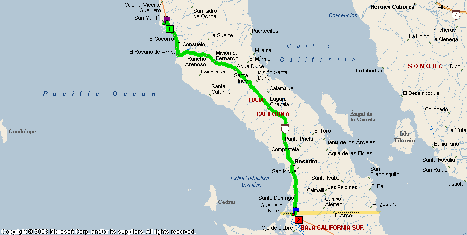
San Quintin to Guerrero Negro
3/4/05
Whale Watching Album
This leg takes me through the central section of Baja. Until I cross the 28 parallel, I’m still in Baja California, and I’ll be traveling down the spine of the peninsula. The highway turns inland at El Rosario and doesn’t rejoin the coast until Guerrero Negro, which is just a few miles across the border into Baja Sur. Guerrero Negro (Black Warrior) is named after a shipwreck. It’s one of the newest towns on the Baja; it is a company town that was founded in 1955 to extract salt from seawater. The shallow lagoons are perfect for this. Recently it’s become famous for the gray whales that migrate here every year to mate and give birth. That’s also the main reason for my stop here.
ROAD REPORT: The highway is as described in previous entries but, other than the narrow lanes, it’s in pretty good shape. There are short sections that are very rough but no pothole problems. The rough sections appear out of nowhere, with no obvious reason. They aren’t in a flood area, a slide area, or even a hilly area. They are on nice flat ground. It’s as if the contractor just decided to skimp on material for that section. One thing I learned on this leg is to watch for the “Vado” signs. These indicate an arroyo or wash ahead that may or may not have water in it.
The El Rosario Pemex station appears to be accepting US credit cards. There is a large banner over the pay window (the first one of those I’ve seen down here) advertising Visa and MasterCard. Be careful when leaving El Rosario, there is a large tope at the southern outskirts that is NOT marked or painted. Boy, that one really caught me by surprise! For years, El Rosario was the end of the pavement and only 4WD vehicles ventured beyond here. Now the Tran-peninsular (Mex-1) takes us all the way to Cabo at the end of the peninsula.
After leaving El Rosario, the road climbs to the top of a high mesa, surprisingly called El Rosario Mesa. At the top (km 54), there is another military checkpoint, also just checking northbound traffic, and then the road drops off the mesa. And I do mean DROP. It was similar to driving off a cliff! That’s how steep the initial grade is! After winding through the valleys, climbing the mountains and dropping back down about 3 or 4 times we came out on top of a mountain ridge at about km 84. The road follows the ridgeline for quite a ways and it’s like driving across the top of the world with spectacular vistas on both sides. The only problem is that there aren’t any pullouts big enough for my rig so I can’t stop and take pictures.
The high valleys, although desert, are green, gold/orange, yellow, and purple. The whole place has exploded with color, thanks to the recent rains. In some places there are whole hillsides awash in a single brilliant color, interspersed with green; others are a potpourri of colors. Even some of the cacti are flowering. This area is also the home of a lot of plant life that I’ve never seen before plus some that I’m familiar with. One looks like the same as the cacti around Phoenix but much larger, I mean HUGE! Another looks like very tall sticks with little leaves growing right out of the main trunk. From a distance, they look like large fuzzy sticks. There aren’t any real branches but some do split into 2 or more smaller trunks and continue upward. They get to about 30 ft high. Another is similar only rather than just one trunk there are dozens of them emanating from the ground at a single location. Each fuzzy trunk writhes outward like the snakes from Medusa’s head.
As I approach Cataviña the landscape changes to one of large granite boulders, but unlike the Anza Borrego area, there is still a wealth of green and flowers in-between the boulder stacks. On my return trip, I’m definitely going to find a place to park and do some hiking and picture taking. Cataviña is just a wide spot in the road but it does have a couple of RV parks that I can spend the night. It was in this area I came to a water filled Vado with unmarked tope’s and an on-coming truck all at the same time. Between standing on the brakes and trying to avoid the truck, I managed to drop my outside wheels off the pavement. I though I was a goner for a minute but I managed to get the wheels back on the pavement without clipping the passing truck and before I hit the water.
About 18 miles out of Catavina the landscape changes again to rolling hills and grassland. The grass is natural, not planted. Right in the middle of all this green is a very large pile of rocks, about 500 ft high. This small mountain is called Cerro Pedregoso (rocky hill) and is a traveler’s landmark. It looks very out of place among the rolling green hills. A few miles farther, the road borders a large dry lakebed and the scenery reverts to desert again.
I found something that’s worse than the oncoming trucks, the ones that come up from behind and pass! They really push me around with their bow wake. Moreover, some of them must be running light because their trailer is waving all over the place. I had two of them pass me together and again I though I was going to lose it. I did drop one wheel off the pavement but recovered quickly.
The guy selling gas out of 55 gallon drums in the back of his pickup is hard at work at the LA Bay intersection. Apparently some people haven’t heard about the “gas gap”; 195 miles with no gas stations.
The desert changes to pure desert as I approach the Guerrero Negro area. Not much of anything growing except some puny scrub. The inspection goes quickly, they look in my portable cooler and the refrigerator and that was it All they were looking for was fruit, no problem with my veggies and they never looked in the freezer. They didn’t spray my wheels so there wasn’t any charge. The Malarrimo RV Park is just minutes away and not a moment too soon, I’m starving. All I’ve had to eat since this morning is a couple of power bars. I kept telling myself that I’d stop and eat somewhere but never seemed to find the right place. The right place is someplace where there isn’t a big drop-off from the road and room to park my rig. There actually were a couple of places I could have stopped but I always seemed to be looking the wrong way until it was too late. When I started this trip I assumed that if I saw a Tecate Beer sign, I’d find a bar or restaurant below it. Wrong! Every type of business imaginable uses the Tecate signs. So now, I don’t even see the damn things. It’s a “cry wolf” thing; I think Tecate shot themselves in the foot on this one when they gave every shanty and lean-to business a sign.
Well, the “gas gap” is behind me and I only used about a quarter tank according to my gauge. Of course the gauge is kind of flaky, it sits on above full forever and then it starts dropping quickly. I’ll find out just how much I really used when I top off before my next leg.
Side notes: Unlike Baja California, which is on Pacific Time, Baja Sur is on Mountain Time. I have no idea why. Also, if you’re wondering why my entries seem to be longer and more detailed now, blame the TV, or lack thereof. From here south my satellite dish doesn’t work so I have plenty of time in the evening to work on this website.
RV PARK REPORT: Malarrimo RV Park. website www.malarrimo.com e-mail Malarrimo@telnor.net. Cost $18/night. Full hook-ups with 15-amp service that is on all the time. However, they warn you not to run things like air conditioners, battery chargers, electric ranges, heaters, or microwaves or you may black out the entire section of town! Not sure if I believe that. I’m in the front lot, just behind the restaurant and on a concrete slab. The back door to the bar is twenty steps away. The shrimp and scallops dinner the first night was outstanding. I’ve found the bank, internet café, market, and the whale-watching tour office, so I guess I’m set for the next couple of days. I also had dinner at the restaurant the last night; the fish burritos were outstanding!
WEATHER REPORT: The weather the first afternoon and evening was very windy. The second day the wind had subsided but it rained most of the morning and then cleared up in the afternoon. The third day was my whale-watching trip and the weather started out overcast and cool. However, by mid morning I was stripping off the heavy coat, it turned out to be a beautiful day; Clear blue skies and mid to upper 70’s with a nice breeze.
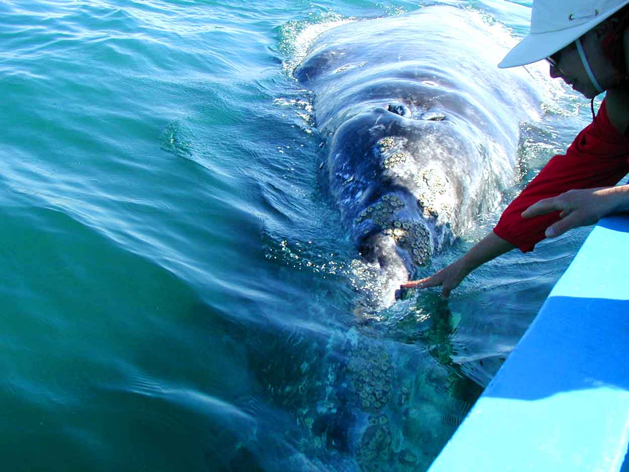
Whale-Watching: This was a trip of a lifetime! (check out the pictures) The gray whales come here every year to give birth and mate. The mothers and calves will come right up to the boat and let you scratch them on the chin! We had 2 mothers and 2 calves join our boat at the same time. The calves are about 16-20 ft long and the mamas are about 3-4 times that size! They played around us for about an hour, then we ran out of time and had to head back. The whales are extremely curious and very friendly. They would splash water on us, blow water on us, and rub up against the boat. Then they would roll over, pass under the boat and splash us with their tail. The mamas spent a lot of time on their backs under the boat, or along side keeping an eye on baby. Both mamas and the babies enjoyed being petted and skritched under their chins. For some reason the whales took a liking to our boat and ignored the other boats that came around when they saw what was going on. Another of their favorite tricks was to exhale while they were a few feet underwater, sending a cascade of bubbles up at us They got me twice! Something people don’t tell you, whales got bad breath! Not as bad a penguins but still pretty bad. Mama whale would actually get baby on her back and push the little one up to the boat. The guide said that this was their “people-watching trip”. The outboard motors didn’t seem to faze them one bit, although ours was turned off most of this time. We tried to back out and let the people on the other boats get a chance to get “up close and personal” but the whales just followed us.
Meanwhile the males were spy-hopping and breaching farther off. This is how they impress the young females, plus its fun. I never got a picture of them because I was too busy with what was going on around the boat.
Well tomorrow, I pull out and head for Santa Rosalia on the Gulf of California side. While there, I’ll backtrack in my toad and check out the cave art at San Ignacio, a date-palm oasis in the middle of the peninsula, and check it out. I’m not stopping at San Ignacio because it’s only about an hour from Santa Rosalia and the RV park in Santa Rosalia has a Laundromat (Autolava). It’s time to do some housekeeping chores.
STAY TUNED.