
La Paz Malecon
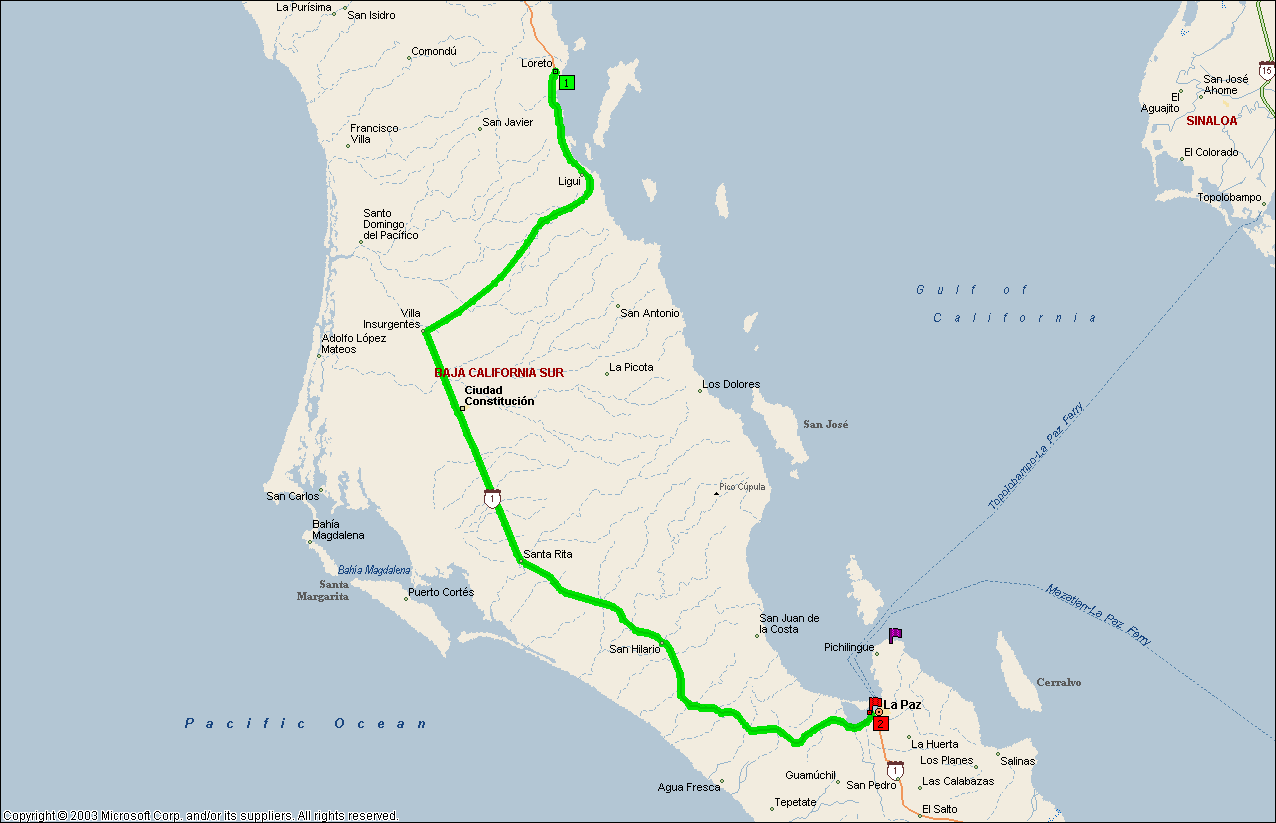
Loreto to
La Paz
3/15/05
This leg of my journey will take me over the Sierra la Giganta (Mexican Sierras), out onto the Magdalena Plan, through Villa Insurgentes and Ciudad Constitución (Ciudad = City) and then back to the east coast of the Gulf of California at La Paz.
ROAD REPORT: The road up the Sierra la Giganta is a twisting, winding road with lots of switchbacks. It really isn’t all that steep but the drop off at the edge of the road can be somewhat unsettling at times. Once you get to the top you are in Arroyo Huatamote which is fairly easy but still has some sharp turns. Look out for wild burros through here, they have a tendency to wander out onto the road and aren’t the slightest bit intimidated by vehicles. The Arroyo leads you out onto the gently sloping Magdalena Plain. The Plain section is fairly straight and slopes gently down. It will take you through a patchwork of desert (or high prairie) and irrigated farming land. The unplowed areas were awash in gold and purple.
At Villa Insurgentes the road takes a 90 degree turn to the left and becomes a 4 lane highway with an actual shoulder. The speed limit on this stretch of road is 80 km/hr, I was doing 100 km/hr and got passed by a car doing at least 140 km/hr. I’ve been noticing ever since I crossed into BCS that a lot of cars don’t have license plates. I wonder what’s with that?
Outside of Ciudad Constitución, I stopped for fuel. This station was the first “self-service I’ve run across. You go up to the pay window and either pre-pay or tell them you are going to fill up. They unlock the pump and you can then zero it yourself and start pumping. There are attendants at the pump islands but they are just for washing windows or any other thing you want them to do, other than pumping gas. That’s a good system in that it eliminates any possible cheating. A local vendor that was selling cowboy hats and leather belts at the pump island walked me through the process so I bought a belt from him (I’ve already got a cowboy hat).
In Ciudad Constitución I ran into the first major use of laterals; these are lanes parallel the main road, but separated from it by a small planting strip and are one way. There is one on each side of the main road. If you want to make a left turn, you have to get onto the lateral to your right at least a block before your turn, and then make your left across both lanes of the main road and across or onto the lateral on the other side of the highway. A few intersections have lights but most have either only a stop sign on the main road or nothing at all, so you’re on your own for crossing over.
On the other side of Ciudad Constitución the road reverted to two lanes with no shoulder; oh well it was nice while it lasted.
RV PARK REPORT: Some northbound travelers told me that, in La Paz, the La Paz RV Park was closed and that the Aquamarina RV Park was very dirty. That left me with the Casa Blanca RV Park. However, when I arrived it was full. They had 2 caravans in at the same time. So I went to the Aquamarina, which actually was my first choice. It turned out to be a real nice place. The attached marina is a mess with all the storm damage (you have to remember they got hit by a hurricane 2 years ago) but the park is great.
AQUAMARINA RV PARK; WEBSITE?; E-MAIL?. $17.81/night: This rate just went up due to a large increase in electrical rates. Owned and operated by Richard and Mary Lou Adcock for the last 50 years. Up until 2001, they also had a viable marina here and ran the Marisla II out of it; Marisla II is a converted USCG Buoy Tender (USCG Columbine, WAGL 208) that Richard and Mary Lou ran as an excursion/dive vessel. The Columbine was built in 1931 for the US Lighthouse Service and became a Coast Guard vessel when the Coast Guard absorbed the Lighthouse Service in 1939. I’m planning a separate page, with lots of pictures, on the history of this grand old vessel. Richard is a Merchant Marine Academy grad (Engineer) and a certified diving instructor, and Mary Lou is the first (and, to date, the only) Mexican female to obtain a captains license. The Marisla II is no longer in service but is still tied up here. Richard has photos of what the Marisla II looked like when he first bought it some 40+ years ago. I’ll stop in on my way back and get copies if he’s found them. The hurricane 2 years ago totally wiped out the piers and floats so the marina currently isn’t a viable business, although there are a couple of catamarans in the yard being worked on and some other boats on trailers around and the boat ramp is still serviceable.
The Church’s guide tells you to go to the end of the road, past a “night gate”, to the main gate on the right. Right now that’s not possible, there has been some erosion damage to the road and from the (first) night gate on isn’t useable for an RV and just barely passable for a car with no turn-around at the end. The night gate is now the main gate until this is fixed. Church’s Guide also says the road is dirt; as of February, all except the last half block is now paved. The city says they’ll fix the erosion at the same time that they pave the rest. No telling how long that’ll take. Until then plan on using the first (night) gate, it’s kept closed but not locked between 8 AM and 6 PM. So if you plan on arriving after 6 or before 8 AM, call first and make arrangements. Guests are given a key so they can come and go after 6.
This place is like a botanical garden, and Mary Lou has planted all of it. Some of the flowering trees and bushes were imported from the Hawaiian Islands. They also had to raise the whole RV park by 6 feet because of seasonal flooding. Of course that was years ago. The roads are hard-packed gravel and there is a concrete slab at each site for a patio. The park is a circle with a swimming pool and covered patio in the center (see photos).
WEATHER REPORT: Needless to say, it’s great!!
LA PAZ : This is one of the largest cities on the Baja and has been continuously occupied by Europeans only since 1811. Earlier attempts at settlements, one by Cortez himself, were a failure due to the lack of cooperation by the local Indians. Currently it’s the seat of government for BCS and really isn’t a tourist destination. But they are working on it. The downtown is full of shops offering watches (stores offering nothing but watches, thousands of them, no telling how many are knock-offs and which ones are the real thing) consumer electronics, and of course the ubiquitous t-shirts. There are hotels, restaurants of all types, and all the major car rental agencies have shops along the malecón. I’ve been told that the malecón has just recently been totally refurbished with the sidewalks tiled and all the statues and trees added. Previously it was a ratty old sidewalk that was broken up or missing in places. They also trucked in the sand from a big beach up the coast. I’d say they did a great job, as it is obviously a favorite for strollers and joggers. And the beach is getting plenty of use.
On my “first day exploratory walk”, one of the things I noticed is the sidewalks (where there are sidewalks). The local residents treat them as an extension of their own property with chairs and tables on the walk, and most of the neighborhood people still walk in the streets. When the city installs a sidewalk, they build it around any existing trees’ and if there aren’t any trees, they plant some. This has resulted in tree limbs blocking the sidewalk and trees that are too young to be tall enough to walk under so you still end up walking in the street. These streets will be nice if and when they trim the mature trees and when the young ones grow up, in about 20, 30 years, or so.
Again, I’ve seen a lot of what looks like uncompleted buildings. A lot of them have ground floors that are finished and occupied, (both residences and shops) but have an uncompleted second or third floor. The explanation I got from the Baja Forum is that there is some kind of tax break they get as long as the construction isn’t completed.
The La Paz beach (along the malecón) has a lot of work going on. There is rock groins spaced out all along the beach, probably for beach erosion control, and they are moving sand from one end of these to the other. There is also a lot of washed up sea grass on the beach; in fact some areas are totally green (see photos) and they have crews raking up this grass and hauling it off. I’d estimate that they have about half of the beach area cleaned up. According to the Baja Forum, this is a seasonal thing (although having crews clean it up is new) and will stop around June.
Another thing I noticed; if you walk inland from the malecón, around the Hotel area, you go up a small rise and then drop down quite a bit into the downtown shopping area. I think this area is actually below sea level! In the downtown section I ran across two young (20’s) American females dressed in beach gear and each carrying one of those kids blow-up donut floats! I haven’t got a clue where they thought they were going since they were headed away from the malecón! Oh, and a lot of the business’s still observe the traditional “Siesta”, they close from about 2 to about 4. This was true even for the internet café that I used and at least one big restaurant on the malecón. I tried to eat there but, since it was just few minutes to 2, they just ignored me. I finally realized what was going on when the bartender started closing the shutters across his bar.
The marinas and boatyards at the south end of the bay are filled with sports/luxury vessels from all over the U.S. and Canada. I spotted vessels from Seattle, San Francisco, Reno, Phoenix, Victoria, and even Halifax. Some aren’t big enough to have made the trip on their own; I wondered about that since I hadn’t seen any sports/Yatch brokers until I spotted the commercial vessel “Latitudes” anchored out with a couple of sports fishing boats on her deck (see photos).
Apparently, around here when the owner of a choice piece of empty property wants to sell it, he builds an 8-foot high solid concrete block wall around it (to keep it from being turned into a dump?) and paints “Se Vende” (for sale) on the wall. I mean solid, no gates or doors, not even a peephole! I’ve seen a couple of these, one of them enclosing about 4 acres of waterfront property! How they show the property to prospective buyers I haven’t a clue. Maybe, since it’s just a vacant lot (I assume), they just use photos. I found one in the downtown area where they had broken a hole in the wall and had started constructing something inside at the same time as they tore down parts of the wall. Since the standard practice in Mexico is to wall in your property with a cement or concrete block wall, I guess already having it in place is a selling point, but I still don’t understand not having a gate somewhere.
For those that are using the Church’s book, Since I’m in a town that actually have these things, I’ve discovered what some of the abbreviations on the Church’s map are; 1) CCC is a supermarket; 2) Ley is another supermarket; 3) Soriana is a large department store, normally the anchor tenant in a shopping mall; 4) A plaza is sometimes a shopping mall (although not always).
I also noticed that the “Alto” (Stop) signs are strictly advisory, no one actually stops at these things unless there are cars at the corners of the cross street! But, according to some tourist pamphlets I read, the Mexicans can get away with that but tourist shouldn’t try it. For those of you who are driving a rental, don’t think the cops (and everyone else) doesn’t know, the rental cars have a different license plate!
I got almost all the way out of La Paz when I realized that I had left my bike back at the RV Park, so I had to turn around (not a simple task with a total length of 50 ft, a wide turning radius, and unable to back up), go back, and get it. Back on the road, I missed my turn for Hwy 1 south and had to turn around again. Bummer!
Well, I’m off to the end of the earth, at least here on the Baja, and that would be Los Cabos, at the tip of Baja.