 Day 53
Day 53
Day 53
 Buffalo Jump
Crowsnest Pass Album
Buffalo Jump Album
Fort Macleod Album
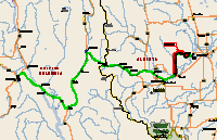
Microsoft Streets and Trips let me down this leg. It had routed me over Crowsnest Pass on Hwy 3 to Hwy 785, across the Oldman River Dam, past the Buffalo Jump and into the Buffalo Plains RV Park. It looked like a piece of cake.
Although there are a couple of construction zones, Crowsnest pass was an easy run. I stopped at one of the turnouts along side a small creek, on the way up the pass for lunch and stopped at Franks Slide for a tour. After leaving the pass the geography changes abruptly from mountain to plains. The first tip-off is the wind farms. They start inside the pass and then fan out almost as far as you can see when you hit the plains. This area is called the “Parkland Prairie Zone” in the Alberta Fishing Regs.
However, after turning onto 785, I ran out of pavement a couple of miles past the dam and didn't get back on it until I got to the Buffalo Jump, about 32 km (see map). The dirt and gravel road wasn't all that bad but I wasn't expecting it and had left the windows of the toad cracked about an inch. I had to vacuum the toad's interior and everything in it when I arrived at the RV park. The sightseeing was better than if I had stayed on 3 though. Streets and Trips is supposed to route me around gravel roads. Oh well, next time I'll double check my route with a local map.
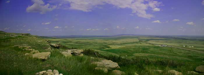
The road takes you across the dam, directly past some vertical wind generators, and a lot of little ranch complexes tucked into the folds of the terrain, which looks fairly flat until you come across these monstrous gullies. I guess that they locate the ranch buildings down in these gullies to get them out of the wind.
Road Report : When coming from the west, don't take 785N unless you don't mind a lot of dust. Although the scenery is more interesting. Other than that, and a couple of construction zones, the Crowsnest highway is a piece of cake. 2 to 3 lanes and well maintained.
As you come across the pass, the highway actually runs across an area called “Frank Slide” (there was another slide area like this earlier in the trip, but smaller). This is where the whole side of a mountain gave way and slide down into the valley, covering the coal town of Frank and killing a bunch of people. The highway was rebuilt across the rubble of the slide. I spent about 2 hours touring the interpretive center. Very interesting.
RV REPORT: Buffalo Plains RV Park (Coast to Coast/GNP) www.buffaloplains.com is 6 km from the Buffalo Jump and about 15 minutes from Fort Macleod . It is a nice little park with power and water at the sites, which are large and fairly level with gravel roads and grass sites. The park has free showers, free internet hookup in the office, free dump station, and a pay laundry. When I asked about having my meds FedEx'ed to me, the owner said that FedEx couldn't seem to find his place so, to be on the safe side, I should have them shipped to the floor and carpet shop in Fort Macleod. It is owned by a friend of his and she receives all of his packages. I got the address and told Mail & Print to ship my stuff, next day delivery.
I toured the “Head-Smashed-In Buffalo Jump” center and learned about the various ways that the Indians hunted and used the buffalo. As the old saw goes about pigs, “They used everything except the squeal”. The “Head-Smashed-In” part of the name doesn't refer to the demise of the buffalo but of a brave that thought it would be cool to watch the buffalo fall from the base of the cliff. He probably would have been OK but that was a very good drive that year and the buffalo stacked up pretty high. He was found under the pile with his skull crushed. The self guided tour of the interpretive center and the upper and lower trails takes about 2 hours. When you follow the lower trail, take the left (or uphill fork. You will come to a spot directly under where they drove the buffalo over. This may appear to be the end of the trail but it isn't, the trail narrows and is a bit overgrown but it actually goes down onto the plains and connects to the lower fork. There are some steep, rocky spots and, when I took it, some areas overgrown with brush so I recommend a good hiking stick. There are the occasional trail marker but the descriptive placards are missing on most. If you do the whole loop it will take about 30-45 minutes. If you're real quiet you will see all kinds of prairie animals and birds. When I was there, mosquitoes weren't a problem but I'm told that, later in the year, a spray-down with Deet is advised.
The rebuilt fort at Fort Macleod is also worth seeing. They also have a "Musical Ride " (local kids on horseback, dressed up in NW Mountie uniforms, and performing synchronized formations, all put to music) but I missed that. Allow about an hour for the fort, (not counting the Musical Ride) and another hour strolling the town and looking at the historic buildings.
I went into Fort Macleod to get a haircut and ended up attending a C&W jam session. In the barber shop two ranchers, also waiting for haircuts, passed an acoustic guitar back and forth, giving everyone in the shop and out on the street renditions of “Texas Ranger”, “Don't let your son grow up to be a cowboy” and other C&W songs. Both were in their 50's and both were excellent musicians and singers. People both inside and outside joined in when appropriate. The barbershop was a typical small town shop, with pictures of high school athletes, local scenic vista's painted on saws, pithy sayings and jokes, and Indian artifacts on the walls and a pot bellied stove and coffee pot in the corner. It is a 2 chair shop and both were in use. I was about 3 rd in line so I had plenty of time to sit and enjoy the music. I felt like it was the early 50's and I was back in Lyle WA again.
There is an internet café/curio shop in Fort Macleod (about 2 blocks east of the Fort) that I frequented that serves an excellent bowl of chili. It is called the Octopus and I highly recommend it. Although not a Hot Spot, they have a spot where you can plug your laptop into the net, have lunch, and watch the traffic go by while you surf the web. They also have about 4 workstations if you don't have a laptop. Cost is about 10 cents a minute ($6.00/hr), which is actually a little cheaper than some of the other places I've stopped at.
While in the area, waiting for my mail/meds to catch up with me, I drove a loop, west on 3 to Hwy 6, then south on 6 through Pincher Creek, to Waterton Lakes National Park . From the park I took Hwy 5 back north to Fort Macleod . The intent was to get some photos, but it rained the whole day. If it hadn't been for the rain I could have got some good pictures. Speaking of my meds, they finally showed up. It took 3 days! It seems that Fort Macleod isn't on FedEx's "overnight" list. It has to go to Calgary and then be trucked down, one truck per day.
WEATHER REPORT: Watch out for thunderstorms, especially at night! I had to get up and close up my big awning in 100 km winds and rain coming at me sideways. I thought it was going to tip the coach over! Other than that it was very comfortable, 19-24 ° C.
Fort Macleod is actually the start (end) of the Redcoat Trail but I won't be following it when I leave here as I'm making a detour north to Drumheller AB and the dinosaur digs and museum. I'll rejoin the Redcoat Trail at Wrentham, on AB-61. This means that I'll miss the section of the trail that goes from Fort Macleod , through Lethbridge and down to Wrentham, about 100 km.